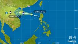
 This screenshot taken from the official website of the Hong Kong Observatory shows the path of tropical storm Nangka.
HONG KONG - The Hong Kong Observatory (HKO) said typhoon signal No. 8 was expected to be raised over Hong Kong at or before 6 am on Tuesday due to Tropical Storm Nangka.
In a tropical cyclone warning issued at 3:45 am on Tuesday, the HKO said the tropical storm was bringing squally showers to the southern coast of the mainland although it was already moving away from the city.
In a tropical cyclone warning issued at 3:45 am, the HKO said the tropical storm was bringing squally showers to the southern coast of the mainland although it was already moving away from the city
“Nangka is gradually moving away from Hong Kong. However, under its combined effect with the northeast monsoon, local winds are still expected to strengthen further. In particular, the southern part of Hong Kong will experience stronger winds,” the HKO said.
“The Observatory will issue the Gale or Storm Signal No. 8 at or before 6 am,” it added.
The HKO said Tropical Storm Nangka was estimated to be about 450 kilometers south of Hong Kong at 4 am Tuesday and was forecast to intensify gradually and move west or west-northwest at about 22 kilometres per hour in the general direction of the vicinity of Hainan Island.
There will be swells and rough seas and members of the public are advised to stay away from the shoreline and not to engage in water sports, the HKO said.
The Observatory earlier issued the Strong Wind Signal No. 3 on Monday afternoon, adding that this meant that winds with mean speeds of 41 to 62 kilometers per hour were expected.
ALSO READ: HKO issues first typhoon signal No. 9 of the year


